
Laßnitzhöhe topographic map
Interactive map
Click on the map to display elevation.
About this map
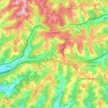
Name: Laßnitzhöhe topographic map, elevation, terrain.
Location: Laßnitzhöhe, Bezirk Graz-Umgebung, Styria, 8301, Austria (47.04315 15.53256 47.08988 15.60941)
Average elevation: 477 m
Minimum elevation: 392 m
Maximum elevation: 567 m
In the area of the watershed between the Mur and Raab lies the gradual transition between central and eastern European climate. The town enjoys a mild, sunny winters and cooler summers. Warm southerly winds are predominantly in the summer and allow stays in the open late into the night. The average annual temperature is higher by 2 °C as usual for the altitude.
Other topographic maps
Click on a map to view its topography, its elevation and its terrain.
Thondorf
Austria > Styria > Bezirk Graz-Umgebung
Thondorf, Gössendorf, Bezirk Graz-Umgebung, Styria, 8077, Austria
Average elevation: 337 m
Dornegg
Austria > Styria > Bezirk Graz-Umgebung > St. Marein bei Graz
Dornegg, St. Marein bei Graz, Bezirk Graz-Umgebung, Styria, 8323, Austria
Average elevation: 438 m
Frohnleiten
Austria > Styria > Bezirk Graz-Umgebung > Frohnleiten
Frohnleiten, Bezirk Graz-Umgebung, Styria, 8130, Austria
Average elevation: 822 m
Raaba
Austria > Styria > Bezirk Graz-Umgebung > Raaba-Grambach
Raaba, Raaba-Grambach, Bezirk Graz-Umgebung, Styria, 8074, Austria
Average elevation: 368 m