Kearns topographic map
Click on the map to display elevation.
Kearns
Kearns, in the mid to late twentieth century, saw rapid growth on the former airbase. The old streets and foundations of buildings built by the military were used as a template for the town, and homes sprang up quickly as Kearns was becoming the first suburb in Salt Lake County. By the 1970s and into the 1980s, suburban development expanded west of the railroad tracks to 5600 West. In the 1990s there were arguments between the residents of Kearns, West Valley City, and West Jordan city over annexation. West Valley City began annexing land west of Kearns and cut the community from future development. West Jordan annexed the Oquirrh Shadows subdivision and the remaining land became the Oquirrh CDP. In the late 1990s West Valley City and West Jordan were having talks to divide what was left of Kearns to divide the community along 5400 south where anything south of the road would belong to West Jordan and anything North would belong to West Valley City. The residents of Kearns raised enough signatures to stop the annexation and leave Kearns' boundaries as they are today. In 2002, the Winter Olympics brought construction of the Olympic Oval at Oquirrh Park. The Olympic Oval was built on a former running track. The Utah Olympic Oval in Kearns was the venue for long-track speed skating events in the 2002 Winter Olympics. Because of its altitude, which gives it the thinnest air of any such facility in the world, and its unique architecture, which allows for close control of temperature and ice conditions, the Oval saw numerous records set during the games. It remains arguably the fastest ice surface in the world. It is used today as a tourist attraction and a recreation spot. The last major housing area constructed in Kearns was an area between 5600 west and 6200 south.
About this map
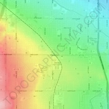
Name: Kearns topographic map, elevation, terrain.
Location: Kearns, Salt Lake County, Utah, 84118, United States (40.63854 -112.04346 40.66758 -111.98646)
Average elevation: 1,408 m
Minimum elevation: 1,338 m
Maximum elevation: 1,503 m
Other topographic maps
Click on a map to view its topography, its elevation and its terrain.
Jordan River OHV/ Modelport State Park
United States > Utah > Salt Lake County > Salt Lake City
Average elevation: 1,286 m





Salt Lake City
United States > Utah > Salt Lake County > Salt Lake City
Salt Lake City has an area of 110.4 square miles (286 km2) and an average elevation of 4,327 feet (1,319 m) above sea level. The lowest point within the boundaries of the city is 4,210 feet (1,280 m) near the Jordan River and the Great Salt Lake, and the highest is Grandview Peak, at 9,410 feet (2,868 m).
Average elevation: 1,625 m
Brighton
United States > Utah > Salt Lake County
Brighton has a high-altitude cold continental climate (Köppen Dsb/Dsc), with dry summers and very snowy winters.
Average elevation: 2,852 m



Silver Lake Summer Resort
United States > Utah > Salt Lake County > Brighton
Average elevation: 2,833 m
Meridian Peak
United States > Utah > Salt Lake County > Salt Lake City
Meridian Peak can be found at the southern end of Elliot Ridge Trail. It can be reached by ascending several hiking trails into the Gore Range. Surprise Lake Trail goes south for 2.6 miles to Surprise Lake, then the Gore Range Trail continues west for 1.9 miles to a junction with the Upper Cataract Lake and…
Average elevation: 1,698 m

Riverton Majestic Village
United States > Utah > Salt Lake County > Riverton
Average elevation: 1,369 m