
Partenen topographic map
Interactive map
Click on the map to display elevation.
About this map
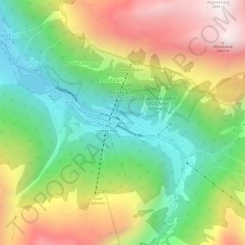
Name: Partenen topographic map, elevation, terrain.
Average elevation: 1,601 m
Minimum elevation: 978 m
Maximum elevation: 2,467 m
Zur Ortschaft gehören auch die Rotten Gufelgut, Innerbofa, Loch und Motta, sowie Bielerhöhe und Zeinisjoch. Dabei sind:
Other topographic maps
Click on a map to view its topography, its elevation and its terrain.
Bieler Höhe
Österreich > Vorarlberg > Bezirk Bludenz > Gemeinde Gaschurn
Bieler Höhe, Gemeinde Gaschurn, Bezirk Bludenz, Vorarlberg, Österreich
Average elevation: 2,169 m