
Wooten Hill topographic map
Interactive map
Click on the map to display elevation.
About this map
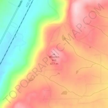
Name: Wooten Hill topographic map, elevation, terrain.
Location: Wooten Hill, DeKalb County, Alabama, United States (34.35837 -85.77168 34.35847 -85.77158)
Average elevation: 387 m
Minimum elevation: 251 m
Maximum elevation: 488 m
Other topographic maps
Click on a map to view its topography, its elevation and its terrain.
Fort Payne
United States > Alabama > DeKalb County
Fort Payne, DeKalb County, Alabama, 35967, United States
Average elevation: 369 m
Pine Ridge
United States > Alabama > DeKalb County
Pine Ridge, DeKalb County, Alabama, United States
Average elevation: 312 m
Mount Brandon
United States > Alabama > DeKalb County
Mount Brandon, DeKalb County, Alabama, United States
Average elevation: 419 m
Mentone
United States > Alabama > DeKalb County > Mentone
Mentone, DeKalb County, Alabama, 35984, United States
Average elevation: 470 m
Shiloh
United States > Alabama > DeKalb County > Shiloh
Shiloh, DeKalb County, Alabama, United States
Average elevation: 378 m