Geolocate

Berceto topographic map

Click on the map to display elevation.

About this map

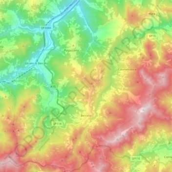
Name: Berceto topographic map, elevation, terrain.

Location: Berceto, Parma, Emilia-Romagna, 43042, Italy (44.46343 9.88739 44.60747 10.07245)

Average elevation: 767 m

Minimum elevation: 225 m

Maximum elevation: 1,473 m

Other topographic maps

Click on a map to view its topography, its elevation and its terrain.

Lozzola

Italy > Emilia-Romagna > Parma > Berceto

Average elevation: 509 m

Campo Rosso

Italy > Emilia-Romagna > Parma > Vallezza

Average elevation: 325 m

Monte Penna

Italy > Emilia-Romagna > Parma > Tornolo

Average elevation: 1,409 m

Santa Maria del Taro

Italy > Emilia-Romagna > Parma > Tornolo

Average elevation: 886 m

Fosio

Italy > Emilia-Romagna > Parma

Average elevation: 339 m

Cavazzola

Italy > Emilia-Romagna > Parma > Berceto

Average elevation: 663 m

Lagrimone

Italy > Emilia-Romagna > Parma

Average elevation: 720 m

Porcigatone

Italy > Emilia-Romagna > Parma > Borgo Val di Taro

Average elevation: 740 m

Vicopò

Italy > Emilia-Romagna > Parma > Parma > Vicopò

Average elevation: 44 m

Gear up for your next adventure:

🦶Anti-Blister Balms - Protect your feet before long topographic expeditions
🥾Walking Shoes - Lightweight walking shoes for countryside and coastal paths
🥾Trekking Poles - Poles to improve stability on uneven terrain
🧭Orienteering Compasses - Accurate compasses for map-based navigation
👕Merino Base Layers - Natural temperature regulation for cold weather hiking and camping

As an Amazon Associate, this site earns from qualifying purchases at no extra cost to you.