
Make a donation
Gear up for your next adventure:
As an Amazon Associate, this site earns from qualifying purchases at no extra cost to you.
Muktinath topographic map
Click on the map to display elevation.
Make a donation
Gear up for your next adventure:
As an Amazon Associate, this site earns from qualifying purchases at no extra cost to you.
Muktinath
Muktinath is a Vishnu temple, sacred to both Hindus and Buddhists. It is located in Muktinath Valley at the foot of the Thorong La mountain pass in Mustang, Nepal. It is one of the world's highest temples (altitude 3,800 m). Within Hinduism, it is one of the 108 Divya Desams, and is the only Divya Desam located outside India. It known as Mukti Kshetra, which literally means the 'liberation arena' (moksh) and is one of the Char Dham in Nepal.[1]
Make a donation
Gear up for your next adventure:
As an Amazon Associate, this site earns from qualifying purchases at no extra cost to you.
About this map
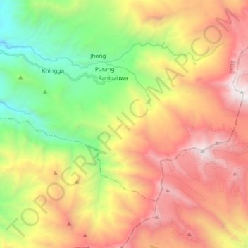
Name: Muktinath topographic map, elevation, terrain.
Average elevation: 4,668 m
Minimum elevation: 3,001 m
Maximum elevation: 6,475 m
Make a donation
Gear up for your next adventure:
As an Amazon Associate, this site earns from qualifying purchases at no extra cost to you.
Other topographic maps
Click on a map to view its topography, its elevation and its terrain.