
Make a donation
Gear up for your next adventure:
As an Amazon Associate, this site earns from qualifying purchases at no extra cost to you.
Marjayoun topographic map
Click on the map to display elevation.
Make a donation
Gear up for your next adventure:
As an Amazon Associate, this site earns from qualifying purchases at no extra cost to you.
About this map
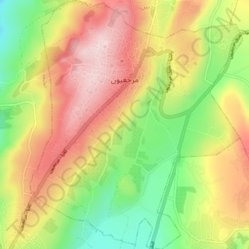
Name: Marjayoun topographic map, elevation, terrain.
Average elevation: 651 m
Minimum elevation: 501 m
Maximum elevation: 784 m
Make a donation
Gear up for your next adventure:
As an Amazon Associate, this site earns from qualifying purchases at no extra cost to you.
Other topographic maps
Click on a map to view its topography, its elevation and its terrain.
Make a donation
Gear up for your next adventure:
As an Amazon Associate, this site earns from qualifying purchases at no extra cost to you.
Make a donation
Gear up for your next adventure:
As an Amazon Associate, this site earns from qualifying purchases at no extra cost to you.
Make a donation
Gear up for your next adventure:
As an Amazon Associate, this site earns from qualifying purchases at no extra cost to you.
Maroun Al Ras
Lebanon > Nabatieh Governorate
Maroun al-Ras is strategically important as it overlooks the surrounding towns. The village's elevation is 911 meters (2,989 feet).
Average elevation: 767 m
Aynata
Lebanon > Nabatieh Governorate
Israeli archaeologist Yohanan Aharoni identified Aynata as ancient En-hazor, and says it appears in the topographical lists of Thutmose III.
Average elevation: 753 m
Make a donation
Gear up for your next adventure:
As an Amazon Associate, this site earns from qualifying purchases at no extra cost to you.
Make a donation
Gear up for your next adventure:
As an Amazon Associate, this site earns from qualifying purchases at no extra cost to you.
Kfour
Lebanon > Nabatieh Governorate
Kfour (Arabic:كفور) is a village and municipality in the Keserwan District of the Keserwan-Jbeil Governorate in Lebanon. Its average elevation is 830 metres (2723 ft) above sea level and its total land area is 426 hectares. Kfour's inhabitants are almost predominantly Maronite Catholic. As of 2008, the…
Average elevation: 404 m
Make a donation
Gear up for your next adventure:
As an Amazon Associate, this site earns from qualifying purchases at no extra cost to you.
Make a donation
Gear up for your next adventure:
As an Amazon Associate, this site earns from qualifying purchases at no extra cost to you.