
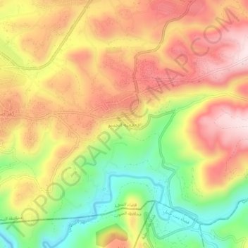
Qaaqaait El Jisr topographic map
Interactive map
Click on the map to display elevation.
About this map
Name: Qaaqaait El Jisr topographic map, elevation, terrain.
Average elevation: 303 m
Minimum elevation: 81 m
Maximum elevation: 490 m
Other topographic maps
Click on a map to view its topography, its elevation and its terrain.
Kafr Kila
Lebanon > Nabatieh Governorate
The total population of the village is about 14,500. The occupants' number increases dramatically during summer. Its altitude is around 700 m from sea level.
Average elevation: 563 m
Maroun Al Ras
Lebanon > Nabatieh Governorate
Maroun al-Ras is strategically important as it overlooks the surrounding towns. The village's elevation is 911 meters (2,989 feet).
Average elevation: 767 m
Aynata
Lebanon > Nabatieh Governorate
Israeli archaeologist Yohanan Aharoni identified Aynata as ancient En-hazor, and says it appears in the topographical lists of Thutmose III.
Average elevation: 753 m
Kfour
Lebanon > Nabatieh Governorate
Kfour (Arabic:كفور) is a village and municipality in the Keserwan District of the Keserwan-Jbeil Governorate in Lebanon. Its average elevation is 830 metres (2723 ft) above sea level and its total land area is 426 hectares. Kfour's inhabitants are almost predominantly Maronite Catholic. As of 2008, the…
Average elevation: 404 m