
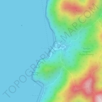
Kerachut Beach topographic map
Interactive map
Click on the map to display elevation.
About this map
Name: Kerachut Beach topographic map, elevation, terrain.
Average elevation: 93 m
Minimum elevation: -1 m
Maximum elevation: 395 m
Other topographic maps
Click on a map to view its topography, its elevation and its terrain.
Guar Perahu
Guar Perahu, Penanti, Central Seberang Perai District, Seberang Perai, Penang, 14400, Malaysia
Average elevation: 13 m
Sungai Juru
Malaysia > Penang > Bukit Mertajam
Sungai Juru, Bukit Mertajam, Central Seberang Perai District, Seberang Perai, Penang, 14000, Malaysia
Average elevation: 16 m
Bukit Mertajam
Bukit Mertajam, Central Seberang Perai District, Seberang Perai, Penang, 14000, Malaysia
Average elevation: 29 m
Padang Chempedak
Padang Chempedak, North Seberang Perai District, Seberang Perai, Penang, 13300, Malaysia
Average elevation: 9 m
Pengkalan Batu
Malaysia > Penang > Tasek Gelugor
Pengkalan Batu, Tasek Gelugor, North Seberang Perai District, Seberang Perai, Penang, 13300, Malaysia
Average elevation: 7 m
Sungai Duri
Sungai Duri, South Seberang Perai District, Seberang Perai, Penang, 14200, Malaysia
Average elevation: 33 m
Sungai Lembu
Sungai Lembu, Central Seberang Perai District, Seberang Perai, Penang, 09000, Malaysia
Average elevation: 46 m
Andaman Island
Malaysia > Penang > George Town
Andaman Island, George Town, North-East, Penang, Malaysia
Average elevation: 2 m
Kampung Guar Kepah
Malaysia > Penang > Bumbung Lima
Kampung Guar Kepah, Bumbung Lima, North Seberang Perai District, Seberang Perai, Penang, 08600, Malaysia
Average elevation: 4 m
Air Itam
Malaysia > Penang > George Town
Air Itam, George Town, North-East, Penang, 11060, Malaysia
Average elevation: 252 m
Parit Tepi TNB
Malaysia > Penang > Tanah Liat > Kampung Tok Elong
Parit Tepi TNB, Kampung Tok Elong, Tanah Liat, Central Seberang Perai District, Seberang Perai, Penang, 14400, Malaysia
Average elevation: 8 m
Kolam Takungan Banjir S10
Malaysia > Penang > George Town
Kolam Takungan Banjir S10, Kampung Merdeka, George Town, North-East, Penang, Malaysia
Average elevation: 4 m
Sungai Keluang
Malaysia > Penang > Bayan Lepas
Sungai Keluang, Bayan Baru, Bayan Lepas, South-West, Penang, Malaysia
Average elevation: 8 m
Batu Kawan
Batu Kawan, South Seberang Perai District, Seberang Perai, Penang, 14110, Malaysia
Average elevation: 5 m
George Town
George Town, North-East, Central George Town, Penang, Malaysia
Average elevation: 53 m
Kampung Masjid
Malaysia > Penang > Teluk Kumbar
Kampung Masjid, Teluk Kumbar, Southwest Penang Island District, Penang, 11920, Malaysia
Average elevation: 91 m
Kampung Bagan Buaya
Kampung Bagan Buaya, Changkat, South Seberang Perai District, Seberang Perai, Penang, 14200, Malaysia
Average elevation: 5 m
Kampung Lima Kongsi
Kampung Lima Kongsi, Valdor, South Seberang Perai District, Seberang Perai, Penang, 14200, Malaysia
Average elevation: 44 m
Kampung Baru
Malaysia > Penang > Bukit Mertajam
Kampung Baru, Bukit Mertajam, Central Seberang Perai District, Seberang Perai, Penang, 14000, Malaysia
Average elevation: 14 m
Gertak Sanggul
Gertak Sanggul, Southwest Penang Island District, Penang, 11910, Malaysia
Average elevation: 85 m
Bukit Genting
Bukit Genting, Southwest Penang Island District, Penang, 11920, Malaysia
Average elevation: 102 m
Kampung Madrasah Sungai Dua
Kampung Madrasah Sungai Dua, Sungai Dua, Northeast Penang Island District, Penang, Malaysia
Average elevation: 56 m
Bukit Gambir
Malaysia > Penang > Bayan Lepas
Bukit Gambir, Bayan Lepas, Southwest Penang Island District, Penang, 11920, Malaysia
Average elevation: 206 m
Penang Island
Penang Island, Southwest Penang Island District, Penang, Malaysia
Average elevation: 69 m
Penang Hill
Malaysia > Penang > George Town
Penang Hill, George Town, Timur Laut, Penang, 11500, Malaysia
Average elevation: 564 m
Simpang Ampat
Simpang Ampat, South Seberang Perai District, Seberang Perai, Penang, 14100, Malaysia
Average elevation: 8 m
North-East
Malaysia > Penang > George Town
North-East, George Town, Penang, Malaysia
Average elevation: 99 m
Penang Hill
Malaysia > Penang > George Town > Ayer Itam
Penang Hill, Jalan Balik Pulau, Hye Keat Estate, Ayer Itam, George Town, North-East, Penang, 11060, Malaysia
Average elevation: 436 m
South-West
Malaysia > Penang > George Town
South-West, George Town, Penang, Malaysia
Average elevation: 55 m
Ladang Chip Joo
Malaysia > Penang > Bukit Mertajam
Ladang Chip Joo, Bukit Mertajam, Central Seberang Perai District, Seberang Perai, Penang, 14000, Malaysia
Average elevation: 7 m
Pearl Hill Peak
Pearl Hill Peak, Northeast Penang Island District, Penang, 11200, Malaysia
Average elevation: 28 m
Kampung Teluk
Malaysia > Penang > Butterworth
Kampung Teluk, Butterworth, North Seberang Perai District, Seberang Perai, Penang, 13800, Malaysia
Average elevation: 4 m
Bayan Lepas
Malaysia > Penang > George Town
Bayan Lepas, South-West, Penang, 11960, Malaysia
Average elevation: 51 m
Central Seberang Perai District
Central Seberang Perai District, Seberang Perai, Penang, Malaysia
Average elevation: 20 m
Balik Pulau
Balik Pulau, Southwest Penang Island District, Penang, 11000, Malaysia
Average elevation: 136 m
Sungai Ara Linear Park
Sungai Ara Linear Park, Desa Ria, Sungai Ara, Southwest Penang Island District, Penang, Malaysia
Average elevation: 62 m
Nibong Tebal
Nibong Tebal, South Seberang Perai District, Seberang Perai, Penang, 14300, Malaysia
Average elevation: 6 m
Teluk Kumbar
Teluk Kumbar, Southwest Penang Island District, Penang, 11920, Malaysia
Average elevation: 76 m
Kampung Sungai Rambai
Malaysia > Penang > Bukit Mertajam
Kampung Sungai Rambai, Bukit Mertajam, Central Seberang Perai District, Seberang Perai, Penang, 14000, Malaysia
Average elevation: 13 m
Sungai Kechil
Sungai Kechil, South Seberang Perai District, Seberang Perai, Penang, 14300, Malaysia
Average elevation: 18 m
Penang National Park
Penang National Park, Jalan Hassan Abas, Teluk Bahang, Southwest Penang Island District, Penang, 11050, Malaysia
Average elevation: 75 m
Kampung Sanglang
Kampung Sanglang, South Seberang Perai District, Seberang Perai, Penang, 14300, Malaysia
Average elevation: 5 m
Taman Kejiranan Persiaran Pantai Jerjak 10
Taman Kejiranan Persiaran Pantai Jerjak 10, Sungai Nibong, Southwest Penang Island District, Penang, Malaysia
Average elevation: 7 m
Armenian Park
Malaysia > Penang > George Town
Armenian Park, Little India, George Town, Northeast Penang Island District, Penang, 10200, Malaysia
Average elevation: 5 m
South Seberang Perai District
South Seberang Perai District, Seberang Perai, Penang, Malaysia
Average elevation: 29 m
Kampung Melayu Machang Bubok
Malaysia > Penang > Kampung Melayu Machang Bubok
Kampung Melayu Machang Bubok, Central Seberang Perai District, Province Wellesley, Penang, Malaysia
Average elevation: 35 m
Permatang Janggus
Malaysia > Penang > Permatang Pauh
Permatang Janggus, Permatang Pauh, Central Seberang Perai District, Seberang Perai, Penang, 13500, Malaysia
Average elevation: 4 m