Geolocate

Mosul topographic map

Click on the map to display elevation.

About this map

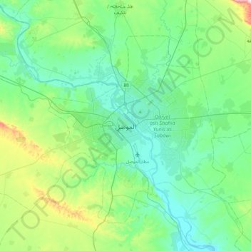
Name: Mosul topographic map, elevation, terrain.

Location: Mosul, Mosul Central Subdistrict, Mosul District, Nineveh Governorate, 14447, Iraq (36.18158 42.96914 36.50158 43.28914)

Average elevation: 282 m

Minimum elevation: 196 m

Maximum elevation: 608 m

Other topographic maps

Click on a map to view its topography, its elevation and its terrain.

Mosul District

Iraq > Nineveh Governorate

Average elevation: 275 m

Badush Dam

Iraq > Nineveh Governorate > rest

Average elevation: 255 m

Atrush

Iraq > Nineveh Governorate

Average elevation: 832 m

Abas Rajab

Iraq > Nineveh Governorate

Average elevation: 230 m

Qaim

Iraq > Nineveh Governorate

Average elevation: 293 m

Hanur

Iraq > Nineveh Governorate

Average elevation: 355 m

Mosul District

Iraq > Nineveh Governorate

Average elevation: 275 m

Kabtan

Iraq > Nineveh Governorate

Average elevation: 252 m

Hatra

Iraq > Nineveh Governorate > Al Hadar

Average elevation: 196 m

Khorsabad

Iraq > Nineveh Governorate > Khursabad

Average elevation: 307 m

Tel Afar District

Iraq > Nineveh Governorate

Average elevation: 407 m

Gear up for your next adventure:

🥼Base Layers - Thermal base layers for temperature regulation
🛰️Handheld GPS Devices - Reliable GPS units for hiking and outdoor navigation
📱Rugged Phone Cases - Heavy-duty protection for smartphones used as secondary GPS tools
🦟Anti-Midge & Tick Repellent - Vital for hiking in the Scottish Highlands during summer
🛑Emergency Bivvy Bags - Heat-reflective survival bags for unexpected nights out

As an Amazon Associate, this site earns from qualifying purchases at no extra cost to you.