
Make a donation
Gear up for your next adventure:
As an Amazon Associate, this site earns from qualifying purchases at no extra cost to you.
Gorey topographic map
Click on the map to display elevation.
Make a donation
Gear up for your next adventure:
As an Amazon Associate, this site earns from qualifying purchases at no extra cost to you.
Gorey
The town was granted a charter as a borough in 1619, under the name Newborough. However, as noted in A Topographical Dictionary of Ireland (published in 1837 by Samuel Lewis) and in Wexford Guide and Directory (published by George Henry Bassett in 1885), this name "never [grew] into general use" as the "inhabitants did not take kindly to the name chosen for the town".
Make a donation
Gear up for your next adventure:
As an Amazon Associate, this site earns from qualifying purchases at no extra cost to you.
About this map
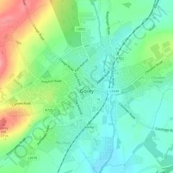
Name: Gorey topographic map, elevation, terrain.
Average elevation: 60 m
Minimum elevation: 28 m
Maximum elevation: 126 m
Make a donation
Gear up for your next adventure:
As an Amazon Associate, this site earns from qualifying purchases at no extra cost to you.
Other topographic maps
Click on a map to view its topography, its elevation and its terrain.
Make a donation
Gear up for your next adventure:
As an Amazon Associate, this site earns from qualifying purchases at no extra cost to you.
Make a donation
Gear up for your next adventure:
As an Amazon Associate, this site earns from qualifying purchases at no extra cost to you.