Geolocate

Inch topographic map

Click on the map to display elevation.

About this map

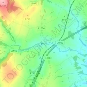
Name: Inch topographic map, elevation, terrain.

Location: Inch, The Municipal District of Gorey — Kilmuckridge, County Wexford, Leinster, Ireland (52.72006 -6.25802 52.76006 -6.21802)

Average elevation: 48 m

Minimum elevation: 7 m

Maximum elevation: 132 m

Other topographic maps

Click on a map to view its topography, its elevation and its terrain.

Rosslare

Ireland > County Wexford

Average elevation: 2 m

Gorey

Ireland > County Wexford

Average elevation: 62 m

St. John's

Ireland > County Wexford

Average elevation: 33 m

Arthurstown

Ireland > County Wexford

Average elevation: 35 m

Bridgetown

Ireland > County Wexford

Average elevation: 10 m

Macoyle Lower

Ireland > County Wexford

Average elevation: 30 m

Piercetown

Ireland > County Wexford

Average elevation: 31 m

Slad

Ireland > County Wexford

Average elevation: 21 m

Kilmuckridge

Ireland > County Wexford

Average elevation: 43 m

Ballywater

Ireland > County Wexford

Average elevation: 47 m

Castlemoyle

Ireland > County Wexford

Average elevation: 40 m

Bowling Green

Ireland > County Wexford > New Ross

Average elevation: 40 m

Enniscorthy

Ireland > County Wexford

Average elevation: 31 m

New Ross

Ireland > County Wexford

Average elevation: 39 m

Meelgarrow

Ireland > County Wexford

Average elevation: 119 m

St. Mary's

Ireland > County Wexford > Wexford

Average elevation: 14 m

Rosbercon ED

Ireland > County Wexford > New Ross

Average elevation: 37 m

Bann

Ireland > County Wexford

Average elevation: 52 m

Redhouse

Ireland > County Wexford

Average elevation: 52 m

Gorey

Ireland > County Wexford

The town was granted a charter as a borough in 1619, under the name Newborough. However, as noted in A Topographical Dictionary of Ireland (published in 1837 by Samuel Lewis) and in Wexford Guide and Directory (published by George Henry Bassett in 1885), this name "never [grew] into general use" as the…

Average elevation: 60 m

Wheelagower

Ireland > County Wexford

Average elevation: 136 m

Ballyprecas

Ireland > County Wexford

Average elevation: 94 m

Bunclody Parish

Ireland > County Wexford

Average elevation: 141 m

Glenduff

Ireland > County Wexford

Average elevation: 45 m

Gear up for your next adventure:

🧰First Aid Kits - Essential safety kits for outdoor activities
Lightweight Tents - Compact tents for backpacking and trekking
📷Outdoor Action Cameras - Cameras designed for hiking and adventure
🔪Outdoor Multi-Tools - Versatile tools for gear repairs and food prep in the wild
🧢Hiking Hats - Sun and weather protection for outdoor walks

As an Amazon Associate, this site earns from qualifying purchases at no extra cost to you.