
Balsthal topographic map
Interactive map
Click on the map to display elevation.
About this map
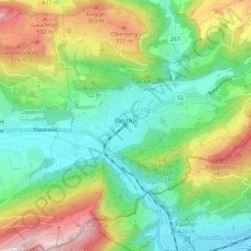
Name: Balsthal topographic map, elevation, terrain.
Location: Balsthal, Bezirk Thal, Amtei Thal-Gäu, Solothurn, 4710, Schweiz (47.28901 7.67040 47.33697 7.74540)
Average elevation: 680 m
Minimum elevation: 453 m
Maximum elevation: 1,112 m
Other topographic maps
Click on a map to view its topography, its elevation and its terrain.
Mümliswil
Schweiz > Solothurn > Amtei Thal-Gäu
Mümliswil, Mümliswil-Ramiswil, Bezirk Thal, Amtei Thal-Gäu, Solothurn, 4717, Schweiz
Average elevation: 744 m
Gänsbrunnen
Schweiz > Solothurn > Amtei Thal-Gäu
Gänsbrunnen, Welschenrohr-Gänsbrunnen, Bezirk Thal, Amtei Thal-Gäu, Solothurn, 4716, Schweiz
Average elevation: 961 m
Herbetswil
Schweiz > Solothurn > Amtei Thal-Gäu
Herbetswil, Bezirk Thal, Amtei Thal-Gäu, Solothurn, 4715, Schweiz
Average elevation: 850 m
Vorder Hammer
Schweiz > Solothurn > Amtei Thal-Gäu > Herbetswil
Vorder Hammer, Herbetswil, Bezirk Thal, Amtei Thal-Gäu, Solothurn, 4715, Schweiz
Average elevation: 837 m
Rinderweid
Schweiz > Solothurn > Amtei Thal-Gäu > Holderbank (SO)
Rinderweid, Holderbank (SO), Bezirk Thal, Amtei Thal-Gäu, Solothurn, 4718, Schweiz
Average elevation: 780 m
Oensingen
Schweiz > Solothurn > Amtei Thal-Gäu
Oensingen, Bezirk Gäu, Amtei Thal-Gäu, Solothurn, 4702, Schweiz
Average elevation: 558 m
Egerkingen
Schweiz > Solothurn > Amtei Thal-Gäu
Egerkingen, Bezirk Gäu, Amtei Thal-Gäu, Solothurn, 4622, Schweiz
Average elevation: 595 m