
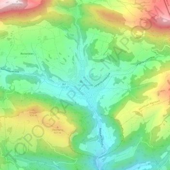
Mümliswil topographic map
Interactive map
Click on the map to display elevation.
About this map
Name: Mümliswil topographic map, elevation, terrain.
Average elevation: 744 m
Minimum elevation: 513 m
Maximum elevation: 1,148 m
Mümliswil liegt auf 556 m ü. M., 3 km nördlich des Bezirkshauptortes Balsthal (Luftlinie). Das Haufendorf erstreckt sich in einem weiten Talkessel am Zusammenfluss von Ramiswiler Bach, Limmerenbach und Rickenbächli, am oberen Eingang in die Klus von Lobisei, am Südfuss der Höhen des Passwangs im Solothurner Jura.
Other topographic maps
Click on a map to view its topography, its elevation and its terrain.
Gänsbrunnen
Schweiz > Solothurn > Amtei Thal-Gäu
Gänsbrunnen, Welschenrohr-Gänsbrunnen, Bezirk Thal, Amtei Thal-Gäu, Solothurn, 4716, Schweiz
Average elevation: 961 m
Herbetswil
Schweiz > Solothurn > Amtei Thal-Gäu
Herbetswil, Bezirk Thal, Amtei Thal-Gäu, Solothurn, 4715, Schweiz
Average elevation: 850 m
Vorder Hammer
Schweiz > Solothurn > Amtei Thal-Gäu > Herbetswil
Vorder Hammer, Herbetswil, Bezirk Thal, Amtei Thal-Gäu, Solothurn, 4715, Schweiz
Average elevation: 837 m
Rinderweid
Schweiz > Solothurn > Amtei Thal-Gäu > Holderbank (SO)
Rinderweid, Holderbank (SO), Bezirk Thal, Amtei Thal-Gäu, Solothurn, 4718, Schweiz
Average elevation: 780 m
Oensingen
Schweiz > Solothurn > Amtei Thal-Gäu
Oensingen, Bezirk Gäu, Amtei Thal-Gäu, Solothurn, 4702, Schweiz
Average elevation: 558 m
Balsthal
Schweiz > Solothurn > Amtei Thal-Gäu
Balsthal, Bezirk Thal, Amtei Thal-Gäu, Solothurn, 4710, Schweiz
Average elevation: 680 m
Egerkingen
Schweiz > Solothurn > Amtei Thal-Gäu
Egerkingen, Bezirk Gäu, Amtei Thal-Gäu, Solothurn, 4622, Schweiz
Average elevation: 595 m