
Make a donation
Gear up for your next adventure:
As an Amazon Associate, this site earns from qualifying purchases at no extra cost to you.
Tokha topographic map
Click on the map to display elevation.
Make a donation
Gear up for your next adventure:
As an Amazon Associate, this site earns from qualifying purchases at no extra cost to you.
About this map
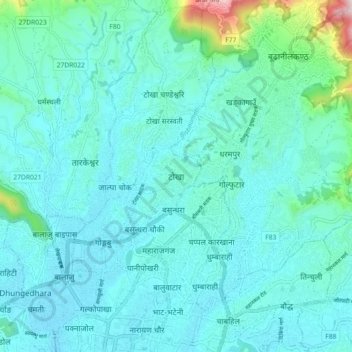
Name: Tokha topographic map, elevation, terrain.
Average elevation: 1,351 m
Minimum elevation: 1,289 m
Maximum elevation: 1,747 m
Make a donation
Gear up for your next adventure:
As an Amazon Associate, this site earns from qualifying purchases at no extra cost to you.
Other topographic maps
Click on a map to view its topography, its elevation and its terrain.
Kathmandu Metropolitan City
Nepal > Bagamati Province > Kathmandu
Kathmandu (Nepali: [ˈkaʈʰmaɳɖu]) is the capital and largest city of Nepal, situated in the central part of the country within the Kathmandu Valley. As per the 2021 Nepal census, it has a population of 845,767 residing in 105,649 households, with approximately 4 million people in the surrounding…
Average elevation: 1,327 m
Kathmandu Metropolitan City
Nepal > Bagamati Province > Kathmandu
Kathmandu (Nepali: [ˌkaʈʰmaɳˈɖu]) is the capital and largest city of Nepal, situated in the central part of the country within the Kathmandu Valley. As per the 2021 Nepal census, it has a population of 845,767 residing in 105,649 households, with approximately 4 million people in the surrounding…
Average elevation: 1,327 m
Make a donation
Gear up for your next adventure:
As an Amazon Associate, this site earns from qualifying purchases at no extra cost to you.
Kathmandu Metropolitan City
Nepal > Bagamati Province > Kathmandu
Kathmandu, officially the Kathmandu Metropolitan City, is the seat of federal government and the most populous city in Nepal. As of the 2021 Nepal census, there were 845,767 inhabitants living in 105,649 households and approximately 4 million people in its surrounding agglomeration. It is located in the…
Average elevation: 1,327 m
Kathmandu Metropolitan City
Nepal > Bagamati Province > Kathmandu
Kathmandu, officially the Kathmandu Metropolitan City, is the seat of federal government and the most populous city in Nepal. As of the 2021 Nepal census, there were 845,767 inhabitants living in 105,649 households and approximately 4 million people in its surrounding agglomeration. It is located in the…
Average elevation: 1,327 m