
Shankharapur topographic map
Interactive map
Click on the map to display elevation.
About this map
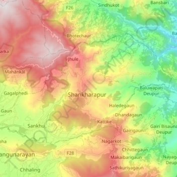
Name: Shankharapur topographic map, elevation, terrain.
Location: Shankharapur, Kathmandu, Bagmati Province, Nepal (27.71599 85.42901 27.79259 85.56596)
Average elevation: 1,520 m
Minimum elevation: 767 m
Maximum elevation: 2,420 m
Other topographic maps
Click on a map to view its topography, its elevation and its terrain.
Kathmandu Metropolitan City
Nepal > Bagmati Province > Kathmandu
Kathmandu, officially the Kathmandu Metropolitan City, is the seat of federal government and the most populous city in Nepal. As of the 2021 Nepal census, there were 845,767 inhabitants living in 105,649 households and approximately 4 million people in its surrounding agglomeration. It is located in the…
Average elevation: 1,327 m
Kathmandu
Nepal > Bagmati Province > Kathmandu
Kathmandu, officially Kathmandu Metropolitan City, is the capital and most populous city of Nepal with 845,767 inhabitants living in 105,649 households in 2021 and 2.9 million people in its urban agglomeration. It is located in the Kathmandu Valley, a large valley in the high plateaus in central Nepal, at an…
Average elevation: 1,538 m