
Hanumana Tahsil topographic map
Interactive map
Click on the map to display elevation.
About this map
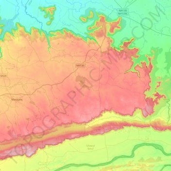
Name: Hanumana Tahsil topographic map, elevation, terrain.
Location: Hanumana Tahsil, Rewa, Madhya Pradesh, 486335, Indien (24.54541 81.83324 24.85819 82.30619)
Average elevation: 292 m
Minimum elevation: 96 m
Maximum elevation: 538 m
Other topographic maps
Click on a map to view its topography, its elevation and its terrain.
Sacher
Indien > Madhya Pradesh > Raisen Tahsil
Sacher, Raisen Tahsil, Raisen District, Madhya Pradesh, Indien
Average elevation: 441 m
Pur
Indien > Madhya Pradesh > Maharajpur Tahsil > Nathpur
Pur, Nathpur, Maharajpur Tahsil, Chhatarpur District, Madhya Pradesh, Indien
Average elevation: 242 m
Hoshangābād
Hoshangābād, Hoshangabad, Madhya Pradesh, 461111, Indien
Average elevation: 427 m
Narmada
Narmada, Hoshangābād, Hoshangabad, Madhya Pradesh, 481880, Indien
Average elevation: 380 m