Geolocate

Limbe topographic map

Click on the map to display elevation.

About this map

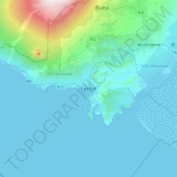
Name: Limbe topographic map, elevation, terrain.

Location: Limbe, Limbé I, Communauté urbaine de Limbé, Fako, Southwest, Cameroon (3.85029 9.04706 4.17029 9.36706)

Average elevation: 329 m

Minimum elevation: -2 m

Maximum elevation: 3,061 m

Other topographic maps

Click on a map to view its topography, its elevation and its terrain.

Limbé I

Cameroon > Southwest > Fako

Average elevation: 186 m

Buea

Cameroon > Southwest > Fako

Because of its location at the foot of Mount Fako, the climate in Buea tends to be humid, with neighbourhoods at higher elevations enjoying cooler temperatures while lower neighbourhoods experience a hotter climate. Extended periods of rainfall, characterized by incessant drizzle, which can last for weeks, are…

Average elevation: 791 m

Tiko

Cameroon > Southwest > Fako

Average elevation: 189 m

Muyuka

Cameroon > Southwest > Fako

Average elevation: 173 m

Gear up for your next adventure:

🔦Waterproof LED Headlamps - Hands-free lighting for evening treks and emergency navigation
👕Merino Base Layers - Natural temperature regulation for cold weather hiking and camping
🧭Professional Hiking Compasses - High-precision liquid-filled compasses for map reading and orientation
🍱Food Containers - Reusable containers for outdoor meals
🧺Microfibre Travel Towels - Fast-drying and compact towels for wild swimming and camping

As an Amazon Associate, this site earns from qualifying purchases at no extra cost to you.