
Make a donation
Gear up for your next adventure:
As an Amazon Associate, this site earns from qualifying purchases at no extra cost to you.
Royan topographic map
Click on the map to display elevation.
Make a donation
Gear up for your next adventure:
As an Amazon Associate, this site earns from qualifying purchases at no extra cost to you.
Royan
Le point culminant de la commune de Royan se situe au lieu-dit la Brandelle, au nord-est de l'agglomération. Il s'agit d'une colline de taille modeste s'élevant à 33 mètres d'altitude.
Make a donation
Gear up for your next adventure:
As an Amazon Associate, this site earns from qualifying purchases at no extra cost to you.
About this map
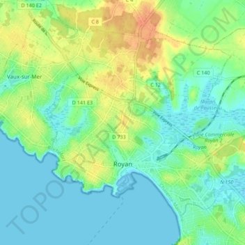
Name: Royan topographic map, elevation, terrain.
Average elevation: 13 m
Minimum elevation: -2 m
Maximum elevation: 36 m
Make a donation
Gear up for your next adventure:
As an Amazon Associate, this site earns from qualifying purchases at no extra cost to you.
Other topographic maps
Click on a map to view its topography, its elevation and its terrain.
La Menounière
France > Nouvelle-Aquitaine > Charente-Maritime > Saint-Pierre-d'Oléron
Average elevation: 3 m
Foulerot
France > Nouvelle-Aquitaine > Charente-Maritime > Saint-Georges-d'Oléron
Average elevation: 3 m
La Croix du Pouilloux
France > Nouvelle-Aquitaine > Charente-Maritime > Sainte-Lheurine
Average elevation: 60 m
Make a donation
Gear up for your next adventure:
As an Amazon Associate, this site earns from qualifying purchases at no extra cost to you.
Plage de Chef de Baie
France > Nouvelle-Aquitaine > Charente-Maritime > La Rochelle
Average elevation: 3 m
Le Berceau
France > Nouvelle-Aquitaine > Charente-Maritime > Meschers-sur-Gironde
Average elevation: 14 m
Make a donation
Gear up for your next adventure:
As an Amazon Associate, this site earns from qualifying purchases at no extra cost to you.
Le Puits Courant
France > Nouvelle-Aquitaine > Charente-Maritime > Allas-Bocage
Average elevation: 69 m
Saint-Gilles d'Oléron
France > Nouvelle-Aquitaine > Charente-Maritime > Saint-Pierre-d'Oléron
Average elevation: 7 m
La Pommeraie des Gaillards
France > Nouvelle-Aquitaine > Charente-Maritime > Port-d'Envaux
Average elevation: 26 m
Moulin de la Croix
France > Nouvelle-Aquitaine > Charente-Maritime > Saint-Pierre-d'Oléron
Average elevation: 6 m
Make a donation
Gear up for your next adventure:
As an Amazon Associate, this site earns from qualifying purchases at no extra cost to you.
Champservé le Haut
France > Nouvelle-Aquitaine > Charente-Maritime > Tonnay-Charente
Average elevation: 13 m
Champservé le Bas
France > Nouvelle-Aquitaine > Charente-Maritime > Tonnay-Charente
Average elevation: 11 m
Les Bagnes
France > Nouvelle-Aquitaine > Charente-Maritime > Saint-Pierre-d'Oléron
Average elevation: 5 m
Make a donation
Gear up for your next adventure:
As an Amazon Associate, this site earns from qualifying purchases at no extra cost to you.
La Sauzaie
France > Nouvelle-Aquitaine > Charente-Maritime > Dampierre-sur-Boutonne
Average elevation: 54 m
Make a donation
Gear up for your next adventure:
As an Amazon Associate, this site earns from qualifying purchases at no extra cost to you.
Les Biraudes
France > Nouvelle-Aquitaine > Charente-Maritime > Saint-Martin-de-Ré
Average elevation: 7 m
Make a donation
Gear up for your next adventure:
As an Amazon Associate, this site earns from qualifying purchases at no extra cost to you.
Le Puits d'Asnières
France > Nouvelle-Aquitaine > Charente-Maritime > Asnières-la-Giraud
Average elevation: 59 m
Le Breuil Malmaud
France > Nouvelle-Aquitaine > Charente-Maritime > Saint-Martin-de-Juillers
Average elevation: 65 m
Le Moulin de la Brande
France > Nouvelle-Aquitaine > Charente-Maritime > Aigrefeuille-d'Aunis
Average elevation: 21 m
Make a donation
Gear up for your next adventure:
As an Amazon Associate, this site earns from qualifying purchases at no extra cost to you.
Make a donation
Gear up for your next adventure:
As an Amazon Associate, this site earns from qualifying purchases at no extra cost to you.
La Fromagère
France > Nouvelle-Aquitaine > Charente-Maritime > Dompierre-sur-Mer
Average elevation: 21 m
Le Treuil Arnaudeau
France > Nouvelle-Aquitaine > Charente-Maritime > Saint-Médard-d'Aunis
Average elevation: 32 m
Make a donation
Gear up for your next adventure:
As an Amazon Associate, this site earns from qualifying purchases at no extra cost to you.
Make a donation
Gear up for your next adventure:
As an Amazon Associate, this site earns from qualifying purchases at no extra cost to you.
Make a donation
Gear up for your next adventure:
As an Amazon Associate, this site earns from qualifying purchases at no extra cost to you.
Le Maurin
France > Nouvelle-Aquitaine > Charente-Maritime > Saint-Martin-d'Ary
Average elevation: 78 m
Make a donation
Gear up for your next adventure:
As an Amazon Associate, this site earns from qualifying purchases at no extra cost to you.
Make a donation
Gear up for your next adventure:
As an Amazon Associate, this site earns from qualifying purchases at no extra cost to you.
Bois des Épinettes
France > Nouvelle-Aquitaine > Charente-Maritime > Nieul-lès-Saintes > Touche-Marteau
Average elevation: 34 m
Château Milan
France > Nouvelle-Aquitaine > Charente-Maritime > Dompierre-sur-Mer
Average elevation: 25 m
Les Pibles
France > Nouvelle-Aquitaine > Charente-Maritime > Saint-Pierre-d'Oléron
Average elevation: 3 m
Make a donation
Gear up for your next adventure:
As an Amazon Associate, this site earns from qualifying purchases at no extra cost to you.
Make a donation
Gear up for your next adventure:
As an Amazon Associate, this site earns from qualifying purchases at no extra cost to you.
Make a donation
Gear up for your next adventure:
As an Amazon Associate, this site earns from qualifying purchases at no extra cost to you.
Saint-Nicolas
France > Nouvelle-Aquitaine > Charente-Maritime > Saint-Dizant-du-Gua
Average elevation: 14 m
Make a donation
Gear up for your next adventure:
As an Amazon Associate, this site earns from qualifying purchases at no extra cost to you.
Les Landes
France > Nouvelle-Aquitaine > Charente-Maritime > La Chapelle-des-Pots
Average elevation: 65 m
Les Gaules
France > Nouvelle-Aquitaine > Charente-Maritime > Saint-Trojan-les-Bains
Average elevation: 3 m
Moulin de Fief Melin
France > Nouvelle-Aquitaine > Charente-Maritime > La Gaconnière
Average elevation: 3 m
Make a donation
Gear up for your next adventure:
As an Amazon Associate, this site earns from qualifying purchases at no extra cost to you.
Make a donation
Gear up for your next adventure:
As an Amazon Associate, this site earns from qualifying purchases at no extra cost to you.
Les Grandes Versennes
France > Nouvelle-Aquitaine > Charente-Maritime > Port-des-Barques
Average elevation: 2 m
Make a donation
Gear up for your next adventure:
As an Amazon Associate, this site earns from qualifying purchases at no extra cost to you.
Le Grand Fief Chagnaud
France > Nouvelle-Aquitaine > Charente-Maritime > Port-des-Barques
Average elevation: 2 m
Bas Rhin
France > Nouvelle-Aquitaine > Charente-Maritime > Saint-Clément-des-Baleines
Average elevation: 1 m
Make a donation
Gear up for your next adventure:
As an Amazon Associate, this site earns from qualifying purchases at no extra cost to you.
Grand-Village
France > Nouvelle-Aquitaine > Charente-Maritime > Le Grand-Village-Plage
Average elevation: 4 m
Make a donation
Gear up for your next adventure:
As an Amazon Associate, this site earns from qualifying purchases at no extra cost to you.
Saint-Jean-d'Angély
France > Nouvelle-Aquitaine > Charente-Maritime > Saint-Jean-d'Angély > Saint-Jean-d'Angély
Average elevation: 38 m
Make a donation
Gear up for your next adventure:
As an Amazon Associate, this site earns from qualifying purchases at no extra cost to you.
Rochefort
France > Nouvelle-Aquitaine > Charente-Maritime > Rochefort > Rochefort
Average elevation: 5 m
La Jagueneau
France > Nouvelle-Aquitaine > Charente-Maritime > Tonnay-Charente > La Jagueneau
Average elevation: 9 m
Make a donation
Gear up for your next adventure:
As an Amazon Associate, this site earns from qualifying purchases at no extra cost to you.
Make a donation
Gear up for your next adventure:
As an Amazon Associate, this site earns from qualifying purchases at no extra cost to you.