
Roslin topographic map
Interactive map
Click on the map to display elevation.
About this map
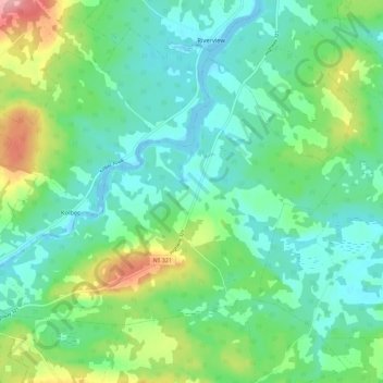
Name: Roslin topographic map, elevation, terrain.
Average elevation: 34 m
Minimum elevation: -6 m
Maximum elevation: 127 m
Other topographic maps
Click on a map to view its topography, its elevation and its terrain.
Nappan
Canada > Nova Scotia > Municipality of the County of Cumberland
Nappan, Municipality of the County of Cumberland, Cumberland County, Nova Scotia, B0L 1C0, Canada
Average elevation: 25 m
Lorneville
Canada > Nova Scotia > Municipality of the County of Cumberland
Lorneville, Municipality of the County of Cumberland, Cumberland County, Nova Scotia, B4H 3X9, Canada
Average elevation: 20 m
Rockley
Canada > Nova Scotia > Municipality of the County of Cumberland
Rockley, Municipality of the County of Cumberland, Cumberland County, Nova Scotia, B0M 1V0, Canada
Average elevation: 24 m
Wentworth Provincial Park
Canada > Nova Scotia > Municipality of the County of Cumberland > Wentworth Station
Wentworth Provincial Park, Valley Road, Wentworth Station, Wentworth, Municipality of the County of Cumberland, Cumberland County, Nova Scotia, B0M 1Z0, Canada
Average elevation: 81 m
Isle Haute
Canada > Nova Scotia > Municipality of the County of Cumberland
Isle Haute, Municipality of the County of Cumberland, Cumberland County, Nova Scotia, Canada
Average elevation: 1 m
Fenwick
Canada > Nova Scotia > Municipality of the County of Cumberland
Fenwick, Municipality of the County of Cumberland, Cumberland County, Nova Scotia, B0L 1C0, Canada
Average elevation: 79 m