
Cer topographic map
Interactive map
Click on the map to display elevation.
Cer
Cer (pronounced [tsɛr]) is a mountain in western Serbia, 30 kilometers from Šabac, 100 kilometers west of Belgrade. The highest peak has an elevation of 689 m (2,260 ft) above sea level. Cer is rich in the Turkey oak forests after which it was named.
About this map
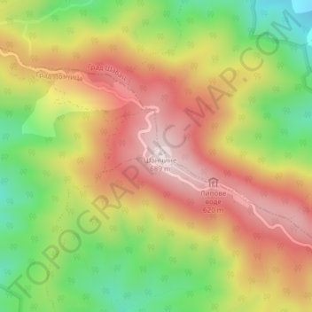
Name: Cer topographic map, elevation, terrain.
Average elevation: 480 m
Minimum elevation: 257 m
Maximum elevation: 681 m
Other topographic maps
Click on a map to view its topography, its elevation and its terrain.
Gučevo
Serbia > Central Serbia > Macva Administrative District > Loznica City > Banja Koviljaca
Gučevo (Serbian Cyrillic: Гучево, pronounced [ɡûːtʃeʋo]) is a mountain in western Serbia, near the town of Loznica, overlooking the Drina river and Banja Koviljača. Its highest peak Crni vrh has an elevation of 779 meters above sea level.
Average elevation: 526 m
Krupanj
Serbia > Central Serbia > Macva Administrative District > Krupanj Municipality
The town lies in western Serbia, at the southern border of the Pannonian plain and Mačva region. It is surrounded by the mountains Jagodnja, Boranja and Sokolska planina, in a valley intersected by several rivers and creeks. In the town itself, the rivers Bogoštica, Čađavica and Kržava conjoin into…
Average elevation: 484 m
Radalj
Serbia > Central Serbia > Macva Administrative District > Mali Zvornik Municipality
Average elevation: 287 m
Brezovice
Serbia > Central Serbia > Macva Administrative District > Krupanj Municipality
Average elevation: 240 m
Ljubovija Municipality
Serbia > Central Serbia > Macva Administrative District > Ljubovija Municipality
Average elevation: 535 m