
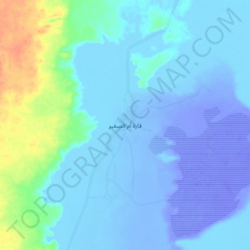
Qaret Um El Saghir topographic map
Interactive map
Click on the map to display elevation.
About this map
Name: Qaret Um El Saghir topographic map, elevation, terrain.
Location: Qaret Um El Saghir, Matruh, Egypt (29.58160 26.45746 29.66160 26.53746)
Average elevation: -14 m
Minimum elevation: -62 m
Maximum elevation: 41 m
Other topographic maps
Click on a map to view its topography, its elevation and its terrain.
Mountainview Ras El Hekma
Mountainview Ras El Hekma, Matruh, Egypt
Average elevation: 12 m
Jabal al-Dakrour
Jabal al-Dakrour, الدكرور, Matruh, Egypt
Average elevation: -7 m
Taghaghien Island
Egypt > Matruh > Siwa Oasis
Taghaghien Island, Siwa Oasis, Matruh, Egypt
Average elevation: -15 m
El Omayed Protectorate
El Omayed Protectorate, Matruh, 51718, Egypt
Average elevation: 45 m