
Sidi Abdel Rahman topographic map
Interactive map
Click on the map to display elevation.
About this map
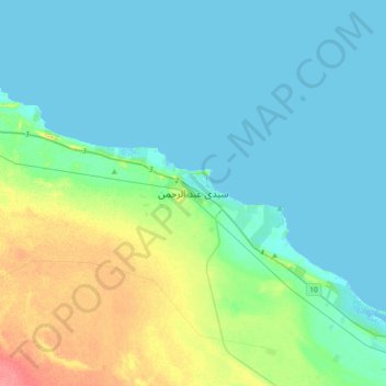
Name: Sidi Abdel Rahman topographic map, elevation, terrain.
Location: Sidi Abdel Rahman, Matruh, 51732, Egypt (30.80515 28.58325 31.12515 28.90325)
Average elevation: 13 m
Minimum elevation: -3 m
Maximum elevation: 61 m
Other topographic maps
Click on a map to view its topography, its elevation and its terrain.
Mountainview Ras El Hekma
Mountainview Ras El Hekma, Matruh, Egypt
Average elevation: 12 m
Jabal al-Dakrour
Jabal al-Dakrour, الدكرور, Matruh, Egypt
Average elevation: -7 m
Taghaghien Island
Egypt > Matruh > Siwa Oasis
Taghaghien Island, Siwa Oasis, Matruh, Egypt
Average elevation: -15 m
El Omayed Protectorate
El Omayed Protectorate, Matruh, 51718, Egypt
Average elevation: 45 m