Geolocate

Clinton topographic map

Click on the map to display elevation.

About this map

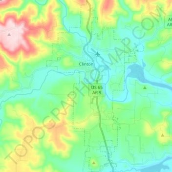
Name: Clinton topographic map, elevation, terrain.

Location: Clinton, Van Buren County, Arkansas, 72031, United States (35.52157 -92.49205 35.63269 -92.41459)

Average elevation: 230 m

Minimum elevation: 138 m

Maximum elevation: 469 m

Other topographic maps

Click on a map to view its topography, its elevation and its terrain.

Bee Branch

United States > Arkansas > Van Buren County

Average elevation: 251 m

Scotland

United States > Arkansas > Van Buren County

Average elevation: 242 m

Gear up for your next adventure:

🧰Survival Kits - Emergency tools for remote environments
🧤Waterproof Overmitts - Extreme weather protection for hikers and mountaineers
🖼️Topographic Map Art - Decorative 3D-effect posters of famous UK peaks and regions
🔋Solar Power Banks - Keep your GPS and phone charged during multi-day expeditions
🪢Paracord - Multi-purpose cord for camping and survival

As an Amazon Associate, this site earns from qualifying purchases at no extra cost to you.