Geolocate

Scotland topographic map

Click on the map to display elevation.

About this map

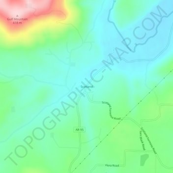
Name: Scotland topographic map, elevation, terrain.

Location: Scotland, Van Buren County, Arkansas, 72141, United States (35.50758 -92.63183 35.54758 -92.59183)

Average elevation: 242 m

Minimum elevation: 182 m

Maximum elevation: 414 m

Other topographic maps

Click on a map to view its topography, its elevation and its terrain.

Clinton

United States > Arkansas > Van Buren County

Average elevation: 230 m

Shirley

United States > Arkansas > Van Buren County

Average elevation: 205 m

Shirley

United States > Arkansas > Van Buren County

Average elevation: 205 m

Clinton

United States > Arkansas > Van Buren County

Average elevation: 230 m

Gear up for your next adventure:

🧢Hiking Hats - Sun and weather protection for outdoor walks
🗺️Scratch-off Peak Maps - Track your progress climbing Munros or Wainwrights
👖Packable Overtrousers - Quick-deploy rain protection for legs in sudden storms
🥫Expedition Meals - Lightweight, high-calorie nutrition for long-distance hikers
🚲Bikepacking Frame Bags - Storage for tools and navigation gear on long off-road rides

As an Amazon Associate, this site earns from qualifying purchases at no extra cost to you.