Geolocate

Shirley topographic map

Interactive map

Click on the map to display elevation.

About this map

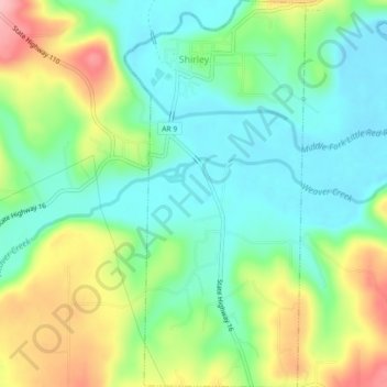
Name: Shirley topographic map, elevation, terrain.

Location: Shirley, Van Buren County, Arkansas, 72153, United States (35.62634 -92.32541 35.66295 -92.30434)

Average elevation: 205 m

Minimum elevation: 152 m

Maximum elevation: 304 m

Other topographic maps

Click on a map to view its topography, its elevation and its terrain.

Scotland

United States > Arkansas > Van Buren County

Scotland, Van Buren County, Arkansas, 72141, United States

Average elevation: 242 m

Clinton

United States > Arkansas > Van Buren County

Clinton, Van Buren County, Arkansas, 72031, United States

Average elevation: 230 m

Van Buren County

United States > Arkansas > Van Buren County

Van Buren County, Arkansas, United States

Average elevation: 296 m

Fairfield Bay

United States > Arkansas > Van Buren County > Fairfield Bay

Fairfield Bay, Van Buren County, Arkansas, 72088, United States

Average elevation: 230 m

Fairfield Bay

United States > Arkansas > Van Buren County > Fairfield Bay > Fairfield Bay

Fairfield Bay, Van Buren County, Arkansas, 72088, United States

Average elevation: 225 m