
Yaoundé II topographic map
Interactive map
Click on the map to display elevation.
About this map
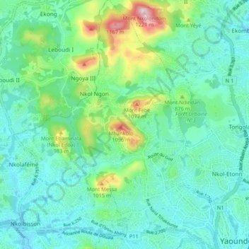
Name: Yaoundé II topographic map, elevation, terrain.
Location: Yaoundé II, Yaoundé, Mfoundi, Région du Centre, Cameroun (3.86643 11.46585 3.94730 11.51476)
Average elevation: 799 m
Minimum elevation: 691 m
Maximum elevation: 1,189 m
Other topographic maps
Click on a map to view its topography, its elevation and its terrain.
Cité Verte
Cameroun > Région du Centre > Mfoundi > Yaoundé
Cité Verte, Yaoundé II, Yaoundé, Mfoundi, Région du Centre, Cameroun
Average elevation: 760 m