
Tobacco topographic map
Interactive map
Click on the map to display elevation.
About this map
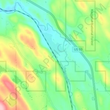
Name: Tobacco topographic map, elevation, terrain.
Location: Tobacco, Lincoln County, Montana, 59917, United States (48.81119 -114.99689 48.85119 -114.95689)
Average elevation: 873 m
Minimum elevation: 813 m
Maximum elevation: 991 m
Other topographic maps
Click on a map to view its topography, its elevation and its terrain.
Libby
United States > Montana > Lincoln County
According to the United States Census Bureau, the city has an area of 1.95 square miles (5.05 km2), of which 1.91 square miles (4.95 km2) is land and 0.04 square miles (0.10 km2) is water. Libby is in the Kootenai National Forest, between the Cabinet Mountains to the south and the Purcell Mountains to the…
Average elevation: 676 m