
Make a donation
Gear up for your next adventure:
As an Amazon Associate, this site earns from qualifying purchases at no extra cost to you.
Chipinge topographic map
Click on the map to display elevation.
Make a donation
Gear up for your next adventure:
As an Amazon Associate, this site earns from qualifying purchases at no extra cost to you.
Chipinge
Pockets of mid-elevation evergreen forest occur on a few eastward-facing mountain slopes in the district, where the mountains create orographic precipitation from winds coming from the Indian Ocean.
Make a donation
Gear up for your next adventure:
As an Amazon Associate, this site earns from qualifying purchases at no extra cost to you.
About this map
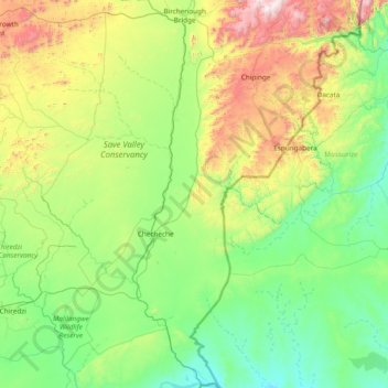
Name: Chipinge topographic map, elevation, terrain.
Location: Chipinge, Manicaland Province, Zimbabwe (-21.32857 32.13639 -19.90707 32.87554)
Average elevation: 533 m
Minimum elevation: 148 m
Maximum elevation: 1,946 m
Make a donation
Gear up for your next adventure:
As an Amazon Associate, this site earns from qualifying purchases at no extra cost to you.
Other topographic maps
Click on a map to view its topography, its elevation and its terrain.
Make a donation
Gear up for your next adventure:
As an Amazon Associate, this site earns from qualifying purchases at no extra cost to you.