Geolocate

Champerico topographic map

Interactive map

Click on the map to display elevation.

About this map

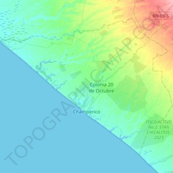
Name: Champerico topographic map, elevation, terrain.

Location: Champerico, Retalhuleu, Guatemala (14.22707 -92.04906 14.43618 -91.77671)

Average elevation: 18 m

Minimum elevation: -1 m

Maximum elevation: 101 m

Other topographic maps

Click on a map to view its topography, its elevation and its terrain.

Municipio de Retalhuleu

Guatemala > Retalhuleu

Municipio de Retalhuleu, Retalhuleu, Guatemala

Average elevation: 139 m

San Andrés Villa Seca

Guatemala > Retalhuleu > San Andrés Villa Seca

San Andrés Villa Seca, Retalhuleu, Guatemala

Average elevation: 462 m

El Asintal

Guatemala > Retalhuleu

El Asintal, Retalhuleu, Guatemala

Average elevation: 359 m

Tulate

Guatemala > Retalhuleu > Tulate

Tulate, San Andrés Villa Seca, Retalhuleu, Guatemala

Average elevation: 5 m

El Hato

Guatemala > Retalhuleu > Municipio de Retalhuleu

El Hato, Municipio de Retalhuleu, Retalhuleu, Guatemala

Average elevation: 75 m