
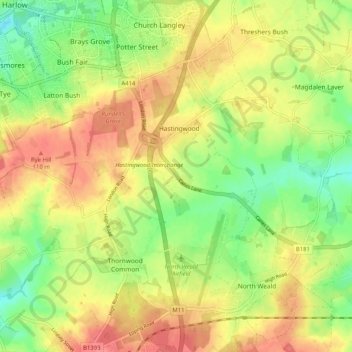
North Weald Bassett topographic map
Interactive map
Click on the map to display elevation.
About this map
Name: North Weald Bassett topographic map, elevation, terrain.
Average elevation: 86 m
Minimum elevation: 52 m
Maximum elevation: 116 m
Essex trails, hiking, mountain biking, running and outdoor activities
Other topographic maps
Click on a map to view its topography, its elevation and its terrain.
Roughtalley's Wood (South) & Epping Forest Woodland Burial Ground
United Kingdom > England > Essex > Epping Forest > Coopersale
Average elevation: 96 m
Nazeing Gate
United Kingdom > England > Essex > Epping Forest > Bumble's Green > Nazeing
Average elevation: 70 m
Passingford Bridge
United Kingdom > England > Essex > Epping Forest > Stapleford Tawney
Average elevation: 53 m
How Green
United Kingdom > England > Essex > Epping Forest > Stapleford Abbotts
Average elevation: 63 m
Steward's Green
United Kingdom > England > Essex > Epping Forest > Coopersale Street > Steward's Green
Average elevation: 76 m
Thornwood Common
United Kingdom > England > Essex > Epping Forest > Thornwood Common
Average elevation: 89 m
Sewardstonebury
United Kingdom > England > Essex > Epping Forest > Sewardstonebury
Average elevation: 51 m