Geolocate

Currie topographic map

Click on the map to display elevation.

About this map

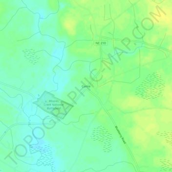
Name: Currie topographic map, elevation, terrain.

Location: Currie, Pender County, North Carolina, 28435, United States (34.44267 -78.12111 34.48267 -78.08111)

Average elevation: 9 m

Minimum elevation: 0 m

Maximum elevation: 18 m

Other topographic maps

Click on a map to view its topography, its elevation and its terrain.

Burgaw

United States > North Carolina > Pender County

Average elevation: 14 m

Burgaw

United States > North Carolina > Pender County

Average elevation: 14 m

Gear up for your next adventure:

📱Rugged Phone Cases - Heavy-duty protection for smartphones used as secondary GPS tools
🥤Hiking Water Bottles - Reusable bottles for hydration on the trail
🧰Survival Kits - Emergency tools for remote environments
🩹Hiking First Aid Kits - Compact medical kits tailored for trail injuries and emergencies
🍱Food Containers - Reusable containers for outdoor meals

As an Amazon Associate, this site earns from qualifying purchases at no extra cost to you.