Geolocate

Topsail Beach topographic map

Click on the map to display elevation.

About this map

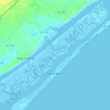
Name: Topsail Beach topographic map, elevation, terrain.

Location: Topsail Beach, Pender County, North Carolina, United States (34.34759 -77.67322 34.40488 -77.59302)

Average elevation: 2 m

Minimum elevation: -4 m

Maximum elevation: 17 m

Other topographic maps

Click on a map to view its topography, its elevation and its terrain.

Currie

United States > North Carolina > Pender County

Average elevation: 9 m

Willard

United States > North Carolina > Pender County

Average elevation: 16 m

D Island

United States > North Carolina > Pender County

Average elevation: 13 m

Gear up for your next adventure:

🕶️Glacier Goggles - Maximum protection for high-altitude snow topography
Lightweight Solo Tents - Backpacking tents designed for wild camping in the UK highlands
📱Phone Mounts for Hiking - Secure mounts to carry your phone on trails
🔋Power Banks - Portable chargers for long outdoor trips
👟Women's Trail Running Shoes - Agile footwear for fell running and technical trails

As an Amazon Associate, this site earns from qualifying purchases at no extra cost to you.