
منشية السواري topographic map
Interactive map
Click on the map to display elevation.
About this map
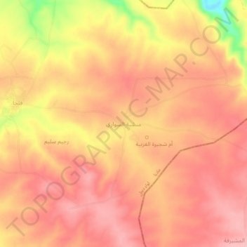
Name: منشية السواري topographic map, elevation, terrain.
Average elevation: 729 m
Minimum elevation: 626 m
Maximum elevation: 768 m
Other topographic maps
Click on a map to view its topography, its elevation and its terrain.
المشرفة
Jordan > Madaba > Dieban Sub-District
المشرفة, Dieban Sub-District, Dieban District, Madaba, Jordan
Average elevation: 582 m