
حیدرآباد topographic map
Interactive map
Click on the map to display elevation.
About this map
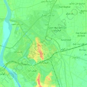
Name: حیدرآباد topographic map, elevation, terrain.
Average elevation: 21 m
Minimum elevation: 10 m
Maximum elevation: 45 m
Other topographic maps
Click on a map to view its topography, its elevation and its terrain.
Hyderabad City Taluka
Pakistan > Sindh > Hyderābād District
Hyderabad City Taluka, Hyderabad District, Hyderabad Division, Sindh, 91000, Pakistan
Average elevation: 22 m
Latifabad
Pakistan > Sindh > Hyderābād District > حیدرآباد
Latifabad, حیدرآباد, Latifabad Taluka, Hyderabad District, Sindh, 91000, Pakistan
Average elevation: 23 m
Tando Allahyar
Pakistan > Sindh > Hyderābād District > Tando Allahyar
Tando Allahyar, Hyderābād District, Sindh, Pakistan
Average elevation: 21 m