
Noumbiel topographic map
Interactive map
Click on the map to display elevation.
About this map
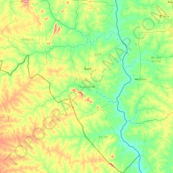
Name: Noumbiel topographic map, elevation, terrain.
Location: Noumbiel, Southwest, Burkina Faso (9.41047 -3.30856 10.18219 -2.68720)
Average elevation: 292 m
Minimum elevation: 211 m
Maximum elevation: 505 m
Other topographic maps
Click on a map to view its topography, its elevation and its terrain.
Koala
Koala, Nagréongo, Oubritenga, Central-Plateau, Burkina Faso
Average elevation: 289 m
Koupéla
Koupéla, Sabou, Boulkiemdé, Central-West, Burkina Faso
Average elevation: 293 m
Petebarabe
Petebarabe, Falagountou, Séno, Sahel, Burkina Faso
Average elevation: 265 m
Fada N'Gourma
Fada N'Gourma, Gourma, East, Burkina Faso
Average elevation: 302 m