
Kỳ Sơn District topographic map
Interactive map
Click on the map to display elevation.
About this map
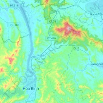
Name: Kỳ Sơn District topographic map, elevation, terrain.
Location: Kỳ Sơn District, Hoà Bình province, 351541, Vietnam (20.77772 105.31751 21.02427 105.46274)
Average elevation: 161 m
Minimum elevation: 10 m
Maximum elevation: 1,010 m
Other topographic maps
Click on a map to view its topography, its elevation and its terrain.
Yên Thủy District
Yên Thủy District, Hoà Bình province, Vietnam
Average elevation: 125 m
Hòa Bình City
Hòa Bình City, Hoà Bình province, Vietnam
Average elevation: 202 m
Kim Bôi District
Vietnam > Hoa Binh province > Kim Bôi District
Kim Bôi District, Hoà Bình province, Vietnam
Average elevation: 260 m
Cao Phong District
Cao Phong District, Hoà Bình province, Vietnam
Average elevation: 330 m
Mai Châu District
Mai Châu District, Hoa Binh province, Vietnam
Average elevation: 559 m
Phương Lâm
Vietnam > Hoa Binh province > Hòa Bình City > Phương Lâm
Phương Lâm, Hòa Bình City, Hoa Binh province, Vietnam
Average elevation: 136 m