
Make a donation
Gear up for your next adventure:
As an Amazon Associate, this site earns from qualifying purchases at no extra cost to you.
Omak topographic map
Click on the map to display elevation.
Make a donation
Gear up for your next adventure:
As an Amazon Associate, this site earns from qualifying purchases at no extra cost to you.
Omak
Elevations around the area range from 780 feet (240 m) above sea level at the mouth of the Okanogan River to 6,774 feet (2,065 m) above sea level at the Moses Mountain. The average elevation is 843 feet (257 m) above sea level according to the United States Geological Survey (USGS). The Moses Mountain, with a summit, sits east of the city, while Little Moses Mountain, located 5,963 feet (1,818 m) above sea level, and Omak Mountain, located 5,749 feet (1,752 m) above sea level, are adjacent to the Moses Mountain. West of the city are the North Cascades, anchored by the Cascade Range. Mountain peaks on the western portion of the Omak area range between 6,000 feet (1,800 m) and 8,000 feet (2,400 m). The Coleman Butte mountain summit—1,450 feet (440 m) above sea level—is located directly adjacent to municipal boundaries.
Make a donation
Gear up for your next adventure:
As an Amazon Associate, this site earns from qualifying purchases at no extra cost to you.
About this map
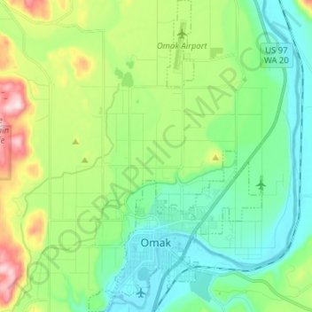
Name: Omak topographic map, elevation, terrain.
Location: Omak, Okanogan County, Washington, 98841, United States (48.39207 -119.55500 48.47666 -119.48419)
Average elevation: 364 m
Minimum elevation: 249 m
Maximum elevation: 658 m
Make a donation
Gear up for your next adventure:
As an Amazon Associate, this site earns from qualifying purchases at no extra cost to you.
Other topographic maps
Click on a map to view its topography, its elevation and its terrain.
Make a donation
Gear up for your next adventure:
As an Amazon Associate, this site earns from qualifying purchases at no extra cost to you.
Make a donation
Gear up for your next adventure:
As an Amazon Associate, this site earns from qualifying purchases at no extra cost to you.
Make a donation
Gear up for your next adventure:
As an Amazon Associate, this site earns from qualifying purchases at no extra cost to you.
Make a donation
Gear up for your next adventure:
As an Amazon Associate, this site earns from qualifying purchases at no extra cost to you.