
Woldia topographic map
Interactive map
Click on the map to display elevation.
About this map
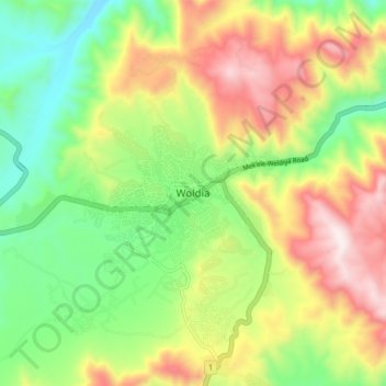
Name: Woldia topographic map, elevation, terrain.
Location: Woldia, ሰሜን ወሎ, Amhara, Ethiopië (11.78885 39.55633 11.86885 39.63633)
Average elevation: 2,014 m
Minimum elevation: 1,651 m
Maximum elevation: 2,510 m
Other topographic maps
Click on a map to view its topography, its elevation and its terrain.
Blauwe Nijl
Ethiopië > Amhara > ጥስ እሳት / Tis Abay
Blauwe Nijl, ጥስ እሳት / Tis Abay, West Gojjam, Amhara, Ethiopië
Average elevation: 1,648 m