
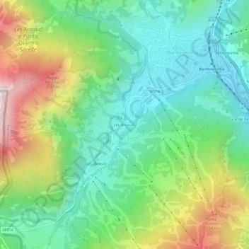
Les Arnauds topographic map
Interactive map
Click on the map to display elevation.
About this map
Name: Les Arnauds topographic map, elevation, terrain.
Location: Les Arnauds, Bardonnèche, Turin, Piémont, 10052, Italie (45.04671 6.66990 45.08671 6.70990)
Average elevation: 1,604 m
Minimum elevation: 1,236 m
Maximum elevation: 2,350 m
Other topographic maps
Click on a map to view its topography, its elevation and its terrain.
Grangia Adret
Italie > Piémont > Turin > Bardonnèche
Grangia Adret, Grangia du Fond, Bardonnèche, Turin, Piémont, Italie
Average elevation: 2,464 m
Melezet
Italie > Piémont > Turin > Bardonnèche
Melezet, Bardonnèche, Turin, Piémont, 10052, Italie
Average elevation: 1,689 m
Millaures
Italie > Piémont > Turin > Bardonnèche
Millaures, Bardonnèche, Turin, Piémont, 10052, Italie
Average elevation: 1,565 m
Rochemolles
Italie > Piémont > Turin > Bardonnèche
Rochemolles, Bardonnèche, Turin, Piémont, Italie
Average elevation: 2,125 m
Les Granges
Italie > Piémont > Turin > Bardonnèche
Les Granges, Bardonnèche, Turin, Piémont, 10052, Italie
Average elevation: 1,755 m
Rifugio Scarfiotti
Italie > Piémont > Turin > Bardonnèche
Rifugio Scarfiotti, Decauville, Bardonnèche, Turin, Piémont, Italie
Average elevation: 2,498 m