
Millaures topographic map
Interactive map
Click on the map to display elevation.
About this map
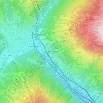
Name: Millaures topographic map, elevation, terrain.
Location: Millaures, Bardonnèche, Turin, Piémont, 10052, Italie (45.05369 6.69952 45.09369 6.73952)
Average elevation: 1,565 m
Minimum elevation: 1,175 m
Maximum elevation: 2,308 m
Bâtie sur le versant nord-ouest du Mont Jaffereau, à 1 345 m d'altitude, Millaures était caractérisée autrefois par un habitat fortement dispersé, réparti sur une douzaine de hameaux distincts.
Other topographic maps
Click on a map to view its topography, its elevation and its terrain.
Grangia Adret
Italie > Piémont > Turin > Bardonnèche
Grangia Adret, Grangia du Fond, Bardonnèche, Turin, Piémont, Italie
Average elevation: 2,464 m
Melezet
Italie > Piémont > Turin > Bardonnèche
Melezet, Bardonnèche, Turin, Piémont, 10052, Italie
Average elevation: 1,689 m
Rochemolles
Italie > Piémont > Turin > Bardonnèche
Rochemolles, Bardonnèche, Turin, Piémont, Italie
Average elevation: 2,125 m
Les Arnauds
Italie > Piémont > Turin > Bardonnèche
Les Arnauds, Bardonnèche, Turin, Piémont, 10052, Italie
Average elevation: 1,604 m
Les Granges
Italie > Piémont > Turin > Bardonnèche
Les Granges, Bardonnèche, Turin, Piémont, 10052, Italie
Average elevation: 1,755 m
Rifugio Scarfiotti
Italie > Piémont > Turin > Bardonnèche
Rifugio Scarfiotti, Decauville, Bardonnèche, Turin, Piémont, Italie
Average elevation: 2,498 m