
Make a donation
Gear up for your next adventure:
As an Amazon Associate, this site earns from qualifying purchases at no extra cost to you.
San Juan Ridge topographic map
Click on the map to display elevation.
Make a donation
Gear up for your next adventure:
As an Amazon Associate, this site earns from qualifying purchases at no extra cost to you.
About this map
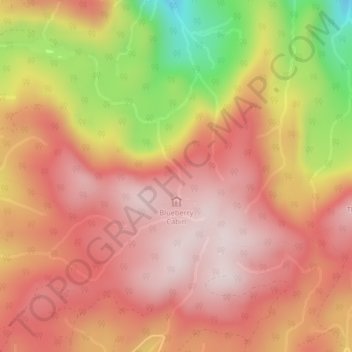
Name: San Juan Ridge topographic map, elevation, terrain.
Average elevation: 841 m
Minimum elevation: 519 m
Maximum elevation: 1,010 m
Make a donation
Gear up for your next adventure:
As an Amazon Associate, this site earns from qualifying purchases at no extra cost to you.
Other topographic maps
Click on a map to view its topography, its elevation and its terrain.
Cadboro Bay
Canada > British Columbia > Capital Regional District > Juan de Fuca Electoral Area
Average elevation: 12 m
Japan Gulch Reservoir
Canada > British Columbia > Capital Regional District > Juan de Fuca Electoral Area
Average elevation: 274 m
Sooke Potholes Regional Park
Canada > British Columbia > Capital Regional District > Juan de Fuca Electoral Area
Average elevation: 298 m
Otter Point
Canada > British Columbia > Capital Regional District > Juan de Fuca Electoral Area
Average elevation: 170 m
Make a donation
Gear up for your next adventure:
As an Amazon Associate, this site earns from qualifying purchases at no extra cost to you.
East Sooke
Canada > British Columbia > Capital Regional District > Juan de Fuca Electoral Area
Average elevation: 55 m
San Juan River
Canada > British Columbia > Capital Regional District > Juan de Fuca Electoral Area
Average elevation: 37 m
Port Renfrew
Canada > British Columbia > Capital Regional District > Juan de Fuca Electoral Area
Average elevation: 97 m
Sooke Hills Wilderness Regional Park
Canada > British Columbia > Capital Regional District > Juan de Fuca Electoral Area
Average elevation: 313 m
Make a donation
Gear up for your next adventure:
As an Amazon Associate, this site earns from qualifying purchases at no extra cost to you.
Boneyard Lake
Canada > British Columbia > Capital Regional District > Juan de Fuca Electoral Area
Average elevation: 282 m
Victoria
Canada > British Columbia > Capital Regional District > Juan de Fuca Electoral Area
Average elevation: 5 m
Sooke Lake
Canada > British Columbia > Capital Regional District > Juan de Fuca Electoral Area
Average elevation: 419 m
Goldstream River
Canada > British Columbia > Capital Regional District > Juan de Fuca Electoral Area
Average elevation: 247 m
Make a donation
Gear up for your next adventure:
As an Amazon Associate, this site earns from qualifying purchases at no extra cost to you.
Fishboat Bay Park
Canada > British Columbia > Capital Regional District > Juan de Fuca Electoral Area
Average elevation: 45 m
Young Lake
Canada > British Columbia > Capital Regional District > Juan de Fuca Electoral Area
Average elevation: 138 m
Botanical Beach
Canada > British Columbia > Capital Regional District > Juan de Fuca Electoral Area
Average elevation: 28 m
Malahat
Canada > British Columbia > Capital Regional District > Juan de Fuca Electoral Area
Average elevation: 345 m
Make a donation
Gear up for your next adventure:
As an Amazon Associate, this site earns from qualifying purchases at no extra cost to you.
Lewis Reef
Canada > British Columbia > Capital Regional District > Juan de Fuca Electoral Area
Average elevation: 1 m
Cadboro Bay
Canada > British Columbia > Capital Regional District > Juan de Fuca Electoral Area
Average elevation: 12 m