
Make a donation
Gear up for your next adventure:
As an Amazon Associate, this site earns from qualifying purchases at no extra cost to you.
Malahat topographic map
Click on the map to display elevation.
Make a donation
Gear up for your next adventure:
As an Amazon Associate, this site earns from qualifying purchases at no extra cost to you.
About this map
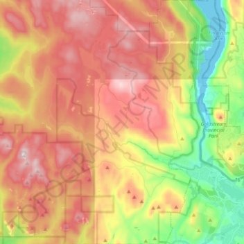
Name: Malahat topographic map, elevation, terrain.
Average elevation: 345 m
Minimum elevation: 0 m
Maximum elevation: 656 m
Make a donation
Gear up for your next adventure:
As an Amazon Associate, this site earns from qualifying purchases at no extra cost to you.
Other topographic maps
Click on a map to view its topography, its elevation and its terrain.
Japan Gulch Reservoir
Canada > British Columbia > Capital Regional District > Juan de Fuca Electoral Area
Average elevation: 274 m
Port Renfrew
Canada > British Columbia > Capital Regional District > Juan de Fuca Electoral Area
Average elevation: 78 m
Leechtown
Canada > British Columbia > Capital Regional District > Juan de Fuca Electoral Area
Average elevation: 237 m
San Juan River
Canada > British Columbia > Capital Regional District > Juan de Fuca Electoral Area
Average elevation: 37 m
Make a donation
Gear up for your next adventure:
As an Amazon Associate, this site earns from qualifying purchases at no extra cost to you.
Shirley
Canada > British Columbia > Capital Regional District > Juan de Fuca Electoral Area
Average elevation: 79 m
San Juan Ridge
Canada > British Columbia > Capital Regional District > Juan de Fuca Electoral Area
Average elevation: 841 m
Goldstream River
Canada > British Columbia > Capital Regional District > Juan de Fuca Electoral Area
Average elevation: 247 m
Young Lake
Canada > British Columbia > Capital Regional District > Juan de Fuca Electoral Area
Average elevation: 138 m
Make a donation
Gear up for your next adventure:
As an Amazon Associate, this site earns from qualifying purchases at no extra cost to you.