Geolocate

Waddan topographic map

Click on the map to display elevation.

About this map

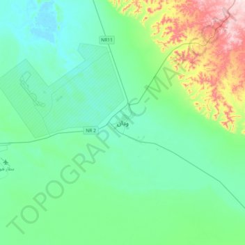
Name: Waddan topographic map, elevation, terrain.

Location: Waddan, District of Al-Jufra, Libya (29.00138 15.98131 29.32138 16.30131)

Average elevation: 304 m

Minimum elevation: 221 m

Maximum elevation: 631 m

Other topographic maps

Click on a map to view its topography, its elevation and its terrain.

Al Fuqaha`

Libya > District of Al-Jufra > Al Fuqaha`

Average elevation: 534 m

Suknah

Libya > District of Al-Jufra > Suknah

Average elevation: 295 m

Gear up for your next adventure:

👟Waterproof Leg Gaiters - Keep mud and water out of your boots in boggy terrain
🎒Hiking Child Carriers - Explore the outdoors with the whole family safely
👕Merino Base Layers - Natural temperature regulation for cold weather hiking and camping
👖Convertible Hiking Trousers - Versatile zip-off pants for changing mountain weather conditions
📷Outdoor Action Cameras - Cameras designed for hiking and adventure

As an Amazon Associate, this site earns from qualifying purchases at no extra cost to you.