
Make a donation
Gear up for your next adventure:
As an Amazon Associate, this site earns from qualifying purchases at no extra cost to you.
Sumas River topographic map
Click on the map to display elevation.
Make a donation
Gear up for your next adventure:
As an Amazon Associate, this site earns from qualifying purchases at no extra cost to you.
About this map
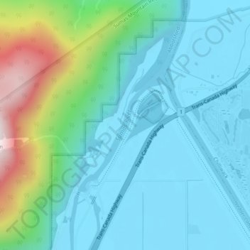
Name: Sumas River topographic map, elevation, terrain.
Average elevation: 167 m
Minimum elevation: -2 m
Maximum elevation: 831 m
Make a donation
Gear up for your next adventure:
As an Amazon Associate, this site earns from qualifying purchases at no extra cost to you.
Other topographic maps
Click on a map to view its topography, its elevation and its terrain.
Stoney Creek Park
Canada > British Columbia > Fraser Valley Regional District > Abbotsford
Average elevation: 40 m
Abbotsford
Canada > British Columbia > Fraser Valley Regional District > Abbotsford
Average elevation: 115 m
Sumas Prairie
Canada > British Columbia > Fraser Valley Regional District > Abbotsford
Average elevation: 159 m
Eagle Mountain
Canada > British Columbia > Fraser Valley Regional District > Abbotsford
Average elevation: 128 m
Make a donation
Gear up for your next adventure:
As an Amazon Associate, this site earns from qualifying purchases at no extra cost to you.
Sumas Prairie
Canada > British Columbia > Fraser Valley Regional District > Abbotsford
Average elevation: 159 m