
Gurley topographic map
Interactive map
Click on the map to display elevation.
About this map
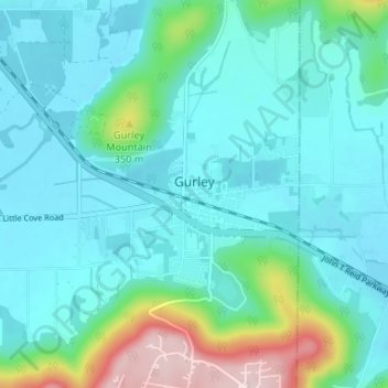
Name: Gurley topographic map, elevation, terrain.
Location: Gurley, Madison County, Alabama, United States (34.67296 -86.39540 34.72706 -86.35823)
Average elevation: 234 m
Minimum elevation: 180 m
Maximum elevation: 471 m
Other topographic maps
Click on a map to view its topography, its elevation and its terrain.
Weatherly Heights
United States > Alabama > Madison County > Huntsville
Weatherly Heights, Huntsville, Madison County, Alabama, 35803, United States
Average elevation: 197 m
Camelot
United States > Alabama > Madison County > Huntsville
Camelot, Huntsville, Madison County, Alabama, 35803, United States
Average elevation: 269 m
Madison
United States > Alabama > Madison County
Madison, Madison County, Alabama, United States
Average elevation: 210 m
Huntsville
United States > Alabama > Madison County
Huntsville, Madison County, Alabama, United States
Average elevation: 232 m
Oak Park
United States > Alabama > Madison County > Huntsville
Oak Park, Huntsville, Madison County, Alabama, 35801, United States
Average elevation: 281 m
South Gate
United States > Alabama > Madison County > Huntsville > South Gate
South Gate, Huntsville, Madison County, Alabama, 35803, United States
Average elevation: 200 m