
Make a donation
Gear up for your next adventure:
As an Amazon Associate, this site earns from qualifying purchases at no extra cost to you.
Polangui topographic map
Click on the map to display elevation.
Make a donation
Gear up for your next adventure:
As an Amazon Associate, this site earns from qualifying purchases at no extra cost to you.
Polangui
known during the early times that the barrio has vas and fertile agricultural land, and because of this, settlers from nearby places migrated to this barrio to venture in agricultural farming. One of the early settlers who migrated to this barrio came from barrio La Medalla, town of Iriga (now a City) of the Province of Camarines Sur; they were so industrious, hardworking and adventurous. They brought along with them their patroness saint, Sta, La Medalla as they settled in this place. And, as a token of gratitude, they donated their patroness saint to the barrio. And with this, the resident decided that Sta. La Medalla be their patroness saint in their barrio in the honor of her, thus, it became barrio La Medalla. The 1st Teniente del barrio” (now known as PABLO BALANG, followed in succession, by SANTOS LAYNES, SANTOS AMOROSO, NEMESIO RAMBOYONG, MARTIN CERVANTES, RESTITUTO BALANG, AMANDO BARRA & presently by OLIVA O. SALCEDO) Barangay La Medalla is situated at the North-Western part of Polangui with a distance of approximately 8.5 kilometers far from centro Poblacion, located along the North: Barangay Lourdes, South: Barangay Apad, Santicon, West: Barangay La Purisima & East: Barangay Kinuartelan. Its topography was plain, Mountainous (Bulod ) and Hilly. Its classification was Poblacion, coastals, along the highway & Interior. Barangay La Medalla is divided into (7) Puroks managed by Purok Leaders & Advisers. It has an exciting complete Elementary School established in 1933 and a high school established on 1992. It has a Barangay Hall, Health Center and a Day Care Center. Residents buy their daily basic provision in a few sari-sari stores but most of the time they prefer to but in a town proper during market day. Today, like other barangay in Polangui, La Medalla is loving forward for progress. The only problem which the residents are facing now is transportation wherein only motorcycle is the only means because of rough roads connecting the barangay to poblacion.
Make a donation
Gear up for your next adventure:
As an Amazon Associate, this site earns from qualifying purchases at no extra cost to you.
About this map
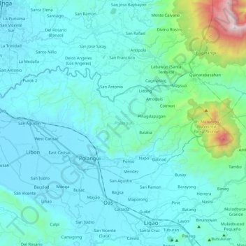
Name: Polangui topographic map, elevation, terrain.
Location: Polangui, Albay, Bicol Region, 4506, Philippines (13.27558 123.39533 13.36992 123.60484)
Average elevation: 193 m
Minimum elevation: 7 m
Maximum elevation: 1,595 m
Make a donation
Gear up for your next adventure:
As an Amazon Associate, this site earns from qualifying purchases at no extra cost to you.
Other topographic maps
Click on a map to view its topography, its elevation and its terrain.
Make a donation
Gear up for your next adventure:
As an Amazon Associate, this site earns from qualifying purchases at no extra cost to you.
Make a donation
Gear up for your next adventure:
As an Amazon Associate, this site earns from qualifying purchases at no extra cost to you.
Make a donation
Gear up for your next adventure:
As an Amazon Associate, this site earns from qualifying purchases at no extra cost to you.
Make a donation
Gear up for your next adventure:
As an Amazon Associate, this site earns from qualifying purchases at no extra cost to you.
Make a donation
Gear up for your next adventure:
As an Amazon Associate, this site earns from qualifying purchases at no extra cost to you.