
Registro topographic map
Interactive map
Click on the map to display elevation.
Registro
Registro is a city near the Atlantic coast of São Paulo, Brazil. The population is 56,393 (2020 est.) in an area of 722 km2. The elevation is 25 m. Registro in Portuguese means register, and this name was given to the city because it was the port from which the earlier settlers registered the gold that was leaving on ships from Brazil headed to Portugal.
About this map
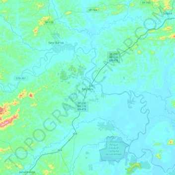
Name: Registro topographic map, elevation, terrain.
Average elevation: 34 m
Minimum elevation: -2 m
Maximum elevation: 412 m
Other topographic maps
Click on a map to view its topography, its elevation and its terrain.
São Paulo
Brazil > São Paulo > Região Metropolitana de São Paulo > São Paulo
São Paulo is in Southeastern Brazil, in southeastern São Paulo State, approximately halfway between Curitiba and Rio de Janeiro. The city is on a plateau placed beyond the Serra do Mar (Portuguese for "Sea Range" or "Coastal Range"), itself a component of the vast region known as the Brazilian Highlands,…
Average elevation: 785 m
Ilha Sumítica
Brazil > São Paulo > Região Metropolitana do Vale do Paraíba e Litoral Norte > Ilhabela
Average elevation: 1 m
Ilha Sumítica
Brazil > São Paulo > Região Metropolitana do Vale do Paraíba e Litoral Norte > Ilhabela
Average elevation: 1 m
Morro do Diabo
Brazil > São Paulo > Teodoro Sampaio
Its summit altitude is 650 metres (2,130 ft) (ASL). Morro do Diabo is an area landmark, seen from the valleys and plains below it. It is located near the cities of Caxias do Sul and Porto Alegre, the state capital.
Average elevation: 397 m
Sitio Borda da Mata
Brazil > São Paulo > Região Metropolitana de São Paulo > Franco da Rocha
Average elevation: 793 m
Praça Bartolomeu de Messina
Brazil > São Paulo > Região Metropolitana de São Paulo > São Paulo
Average elevation: 790 m
Mirante Rio Piracicaba
Brazil > São Paulo > Região Metropolitana de Piracicaba > Piracicaba
Average elevation: 505 m
Paiol Grande
Brazil > São Paulo > Região Metropolitana do Vale do Paraíba e Litoral Norte > São Bento do Sapucaí
Average elevation: 1,339 m
Mogi Mirim
Brazil > São Paulo > Mogi Mirim
Mogi Mirim is a municipality located in the eastern part of São Paulo State, in Brazil. The population is 93,650 (2020 est.) in an area of 498 km². The elevation is 611 m.
Average elevation: 655 m
Rio Paraíba do Sul
Brazil > São Paulo > Região Metropolitana do Vale do Paraíba e Litoral Norte > Guaratinguetá
Average elevation: 546 m
São Bernardo do Campo
Brazil > São Paulo > Região Metropolitana de São Paulo > São Bernardo do Campo
Average elevation: 760 m
São José dos Campos
Brazil > São Paulo > Região Metropolitana do Vale do Paraíba e Litoral Norte
In the urban area, there are rolling plateaus and hills. The lowest elevation in the city (and also in the municipality) is found in the Paraíba do Sul River, at a mean elevation of 550 m.
Average elevation: 634 m
Santo André
Brazil > São Paulo > Região Metropolitana de São Paulo > Santo André
Average elevation: 776 m
Bairro Planalto do Sul
Brazil > São Paulo > Mirante do Paranapanema > Bairro Planalto do Sul
Average elevation: 437 m
Sorocaba
Brazil > São Paulo > Região Metropolitana de Sorocaba > Sorocaba
The terrain is classified as a wavy strands and characterized by local ridges, with an average altitude of 632 meters above the sea level. The highest altitude is 1028 meters, in the Serra de Sao Francisco. The lower altitude is 539 meters, in the valley of the Sorocaba River. Sorocaba is located on the edge…
Average elevation: 662 m