Geolocate

Springdale topographic map

Click on the map to display elevation.

About this map

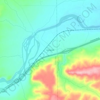
Name: Springdale topographic map, elevation, terrain.

Location: Springdale, Park County, Montana, 59082, United States (45.71746 -110.24428 45.75746 -110.20428)

Average elevation: 1,323 m

Minimum elevation: 1,271 m

Maximum elevation: 1,457 m

Other topographic maps

Click on a map to view its topography, its elevation and its terrain.

Livingston

United States > Montana > Park County

Livingston is located at 45°39′32″N 110°33′49″W / 45.65889°N 110.56361°W / 45.65889; -110.56361 (45.658840, -110.563718), at an elevation of 4,501 feet (1372 m).

Average elevation: 1,421 m

Gardiner

United States > Montana > Park County > Gardiner

Average elevation: 1,866 m

Wilsall

United States > Montana > Park County

Average elevation: 1,550 m

Emigrant

United States > Montana > Park County

Average elevation: 1,580 m

Gardiner

United States > Montana > Park County

Average elevation: 1,931 m

Sunlight Lake

United States > Montana > Park County

Average elevation: 2,755 m

Livingston

United States > Montana > Park County

Livingston is located at 45°39′32″N 110°33′49″W / 45.65889°N 110.56361°W / 45.65889; -110.56361 (45.658840, -110.563718), at an elevation of 4,501 feet (1372 m).

Average elevation: 1,421 m

Gear up for your next adventure:

🧭Professional Hiking Compasses - High-precision liquid-filled compasses for map reading and orientation
🕶️Glacier Goggles - Maximum protection for high-altitude snow topography
🎒Multi-day Trekking Packs - Large capacity backpacks for wild camping and long-distance trails
🔦Outdoor Torches - Reliable torches for night navigation
👕Merino Base Layers - Natural temperature regulation for cold weather hiking and camping

As an Amazon Associate, this site earns from qualifying purchases at no extra cost to you.