Geolocate

Wilsall topographic map

Click on the map to display elevation.

About this map

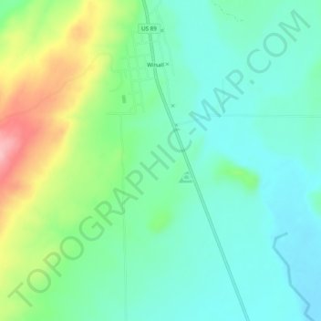
Name: Wilsall topographic map, elevation, terrain.

Location: Wilsall, Park County, Montana, 59086, United States (45.96701 -110.66581 46.00059 -110.65182)

Average elevation: 1,550 m

Minimum elevation: 1,507 m

Maximum elevation: 1,656 m

Other topographic maps

Click on a map to view its topography, its elevation and its terrain.

Urback Place

United States > Montana > Park County

Average elevation: 1,465 m

Emigrant

United States > Montana > Park County

Average elevation: 1,530 m

Granite Peak

United States > Montana > Park County

Average elevation: 3,395 m

Granite Peak

United States > Montana > Park County

Average elevation: 2,660 m

Jardine

United States > Montana > Park County > Jardine

Average elevation: 2,198 m

Gear up for your next adventure:

🩹Hiking First Aid Kits - Compact medical kits tailored for trail injuries and emergencies
🗺️Topographic Maps - Detailed maps showing elevation and terrain features
📢Survival Whistles - Essential safety gear for signaling for help in mountain fog
📦Compression Sacks - Reduce backpack volume efficiently
🚲Cycling GPS Computers - Track elevation and topographic routes on two wheels

As an Amazon Associate, this site earns from qualifying purchases at no extra cost to you.